The official Alaska Highway is 1,387 miles in length. It begins at Mile 0 in Dawson Creek, BC. After traveling 613 miles through British Columbia, the highway enters the Yukon and runs another 577 miles to the Alaska border. From this international border, it is another 200 miles to Delta Junction, the official end of the Alaska Highway, although Alaska Route 2 continues on another 298 miles to Fairbanks, AK.
The Alaska Highway was originally built largely by the U.S. Army Corps of Engineers, in cooperation with the Canadian government, as a supply route during World War II. After the attack on Pearl Harbor, Alaska was recognized as an important strategic defense position against a potential Japanese invasion of the North American mainland.
The Alaska Highway has undergone continuous revision since it was initially completed in November of 1942. It was opened to the public in 1948 and has become a fantastic drive for those looking to experience the joy of a road trip from the Lower 48 to Alaska.
In 2023, I drove from Minnesota to Alaska in my Toyota Tacoma with a DIY Truck Camper. I originally intended to drive up the Alaska Highway and back down via the Cassier Highway, but due to a wildfire, I ended up driving the Alaska Highway in both directions.
If you are planning a drive to Alaska, purchase your Milepost book now and start planning. The MilePost contains maps and mile-by-mile guides for the Alaska Highway, as well as several routes in Canada, and all highways in Alaska. The book also offers tips and tricks for driving in remote regions and provides some history and facts about the areas.
But while a detailed guidebook is great, sometimes you just want to know what the best places to stop are. So here are my favorite stops along the Alaska Highway.

An interactive map can be found by clicking the links below:
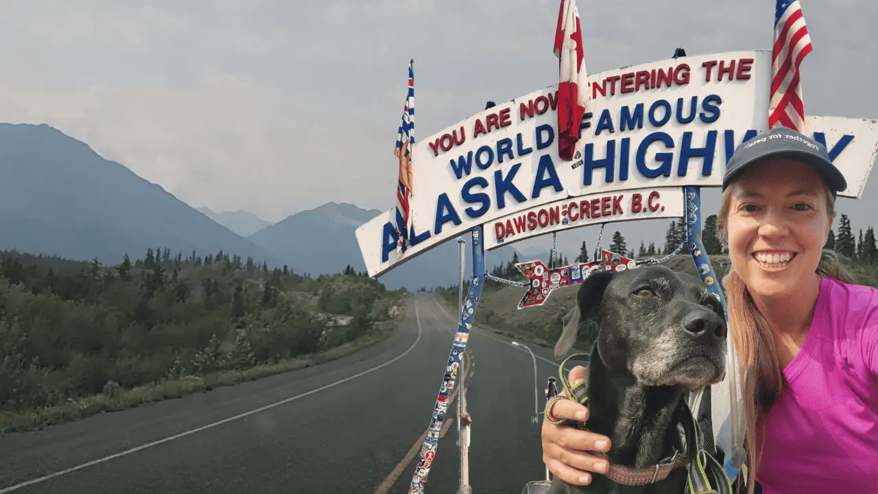
1. Milepost 0
The first stop every traveler on the Alaska Highway needs to make is a cliche stop in Dawson Creek at the sign for the start of the Alaska Highway. Pull into the parking lot and snap your obligatory photo with the famous sign. This is considered the historical Milepost 0 of the Alaska Highway and is next to the traffic circle that connects Highway 97 (Alaska Highway) with Highways 2 and 49.
There is another photo stop about a block away in downtown Dawson City, at 10th Street and 102nd Avenue. The Mile 0 Post has been a favorite photo stop for travelers since it was first erected in the 1940s.


2. Inga Lake Campground
Looking for a nice free campground on your drive? Inga Lake Campground is a nice recreation area with picnic tables, fire rings, and outhouses. There are several nice spots right on the lake, but those were full both times I stopped at this campground. That being said, there were plenty of quiet sites away from the lake for me to choose from.


The turnoff for Inga Lake Campground is located about 90 miles from Milepost 0 in Dawson City (or 144 km). If you are traveling north, you will take a left and drive approximately 2 km down a gravel road. This road is an active service road, so use caution when entering the recreation site. The road is a little rough, so driving slowly is recommended regardless of traffic.
The site is listed on FreeCampsites.net if you want to read more reviews.
3. Sikanni Falls Chief Falls
If Inga Lake isn’t your style and you are looking to get a little further off of the Alaska Highway at a location with a nice little hike, keep driving to Sikanni Chief Falls Protected Area.
This lovely area contains a stunning 98-foot (30-meter) waterfall. A 1.5 km trail leads from the parking area to a scenic viewing area of the river cascading over a steep cliff. Be aware that there are a couple of false trails that have been created by hikers. Many of these still offer good views but aren’t the official trail.
This is also a fun spot to look for mountain goats. We saw one near the falls while we were there.


Several others were free camping on the land near the parking lot, so after a nice hike, this is another great free camping area. No picnic tables or fire rings, but there is an outhouse in the parking lot.
Sikanni Chief Falls Protected Area is located 10.5 miles (15 km) west of the Alaska Highway on Mile 171 road. The area is accessed via a 4×4 gravel/dirt petroleum road. Watch for industrial traffic. And this road was fairly rough. My Toyota Tacoma made it just fine, and I even saw a small van in the free camping area, but do proceed with caution.
4. Tetsa River Lodge and the Best Cinnamon Bun in the Galactic Universe (Historical Mile 375)
At historical mile 375, the Tetsa River Lodge has been serving travelers for over 40 years. While the lodge and campground look nice (and are pet friendly!!), a big reason many travelers stop here is to eat one of the famous cinnamon buns.
The cinnamon buns are made fresh all day long and I can attest that they are amazingly delicious. And big! Worth a stop, especially if you need to fuel up before you hit the trails in Stone Mountain Provincial Park.


5. Stone Mountain Provincial Park
Stone Mountain Provincial Park consists of 25,691 hectares of remote, mountainous terrain along the Alaska Highway, in the northern Rocky Mountains. And for those of us who enjoy hiking, this was the first area of really great hiking right off of the Alaska Highway.
There are a handful of frontcountry hikes, and the park also offers significant backcountry hiking and camping opportunities. Since I didn’t backpack on this trip, I’ll focus on the front country hikes. Both Flower Springs Trial and Summit Peak Trail can be accessed from Summit Lake Campground. Erosion Pillars trail is across from Rocky Crest Lake.
Flower Springs Trail
The Flower Springs Trail is a 5.7 km round-trip. It includes views of alpine lakes, flowers, and waterfalls.
You can start from the campground on Summit Lake Trail (which is 3.5 km in length) or access the official trailhead from the decommissioned radio tower road. Flower Springs trail starts just behind the trailhead kiosk off the radio tower road, where hikers will be able to follow a well-worn path. The first kilometer of trail will take hikers across the lowland areas which is home to lots of wildflowers, especially in the spring. The trail will then lead over a series of natural moraines left from retreating glaciers and ends at Flowers Springs Lake.
It was raining when I arrived at Summit Lake Campground, so Glia and I hiked this trail in the rain. It was a beautiful trail and I would love to hike it again on a sunny day. I didn’t attempt to try this trail again on our drive back to Minnesota, but unfortunately, the access trail from the campground was closed due to bear activity at that time.


Summit Peak Trail
Per the official website, “Summit Peak Trail is a 5 km round-trip hike through lodgepole pine forest. It leads to a spectacular view of the park’s alpine area. This trail is recommended only for physically fit hikers.”
Per the sign at the trailhead, the Summit Peak trail is 6.7 km round trip to the upper viewpoint and 12.5 kilometers round trip to the peak. You should allow 9 hours to reach the peak.
After a creek crossing near the start of the trail, the trail begins a 1km ascent along an open spruce-dominated ridge marked with yellow diamonds. After that, the trail leaves the trees and enters the alpine where hikers should follow rock cairns for approximately 2 km before reaching a viewpoint. You will gain spectacular views there but can choose to continue across the ridge to the next viewpoint. The trail is no longer visible from there, but the peak can be reached by continuing along the ridge of the mountain.
Glia and I attempted this trail twice. The first time was after the rain on our drive up to Alaska. The creek crossing was passable, but we would have gotten wet. And after the hike in the rain to Flower Springs the night before, I elected to pass this hike by and attempt a drier one.
On our way back to Minnesota, we hiked a portion of the trail. The creek was much lower and we crossed without getting our feet wet, but it was pretty windy out. Once the wind got strong enough it felt like we might be blown off of our feet, I turned us around and we headed down. It was a nice trail with great views though.


Erosion Pillars Trail
At just over 1 km long, the Erosion Pillars Trail is suitable for a variety of ability levels. The trailhead is across from Rocky Crest Lake. This trail is named for the tall, thin spire of rocks that can be viewed at the end of the hike.
Baba Canyon Trail
Another option as you are driving through Stone Mountain Provincial Park is Baba Canyon Trail. This trail isn’t listed on Stone Mountain Provincial Park’s website but is in the Northern Rockies Tourism Guide.
The Baba Canyon Trail leads northeast from the highway, staying close to the creek edge and crossing it several times. The trail is only visible in sections, because of the generally rocky terrain, so you can generally just pick your own route close to the creek and follow it upstream. Many small waterfalls, canyons, deep clear pools, and interesting rock formations can be discovered this way.
The trail is about 5.5 km round trip to the first viewpoint and 11 km round trip to the second viewpoint.
Glia and I attempted this hike also on our drive north, but with all of the recent rain the creek crossings were pretty flooded. So we continued our drive north and ultimately hiked in Muncho Lake Provincial Park instead. The start of the trail was pretty though.


Camping at Summit Lake Campground
Stone Mountain Park offers vehicle-accessible campsites in the Summit Lake area. Sites are available on a first-come, first-served basis only. Campsite reservations are not accepted. Camping fees must be paid in cash, so make sure you have some Canadian dollars with you. The cost is $20/night.

A note on dogs in Stone Mountain Provincial Park. Per the park’s website: “Pets must be leashed and are not allowed in beach areas or park buildings. You are responsible for their behavior and must dispose of their excrement. Backcountry areas are not suitable for dogs or any pets due to the potential for problems with bears and other wildlife.”
6. Muncho Lake Provincial Park
After leaving Stone Mountain Park, you will enter Muncho Lake Park. Muncho Lake contains lovely mountains and a stunning, jade-colored lake. The lake’s twelve kilometers of jade-colored water are tinted green by minerals and provide a home to lake trout, arctic grayling, bull trout, and whitefish.
I got gorgeous views of Muncho Lake on the way north, but on our drive home, the area had a lot of wildfire smoke that muted the bright jade color of the lake.


There are two campgrounds along this lake: Strawberry Flats and MacDonald Campgrounds. These campgrounds seemed to fill up faster than the Summit Lake campground.
This park offers most of the vehicle-accessible campsites on a first come, first served basis. Camping fees are payable in cash only at the park. Some campsites can now be reserved through the BC Parks reservations service. Campsites are$20/party/night
There are some hiking options in Muncho Lake Provincial Park. You can view the Tourism Northern Rockies website for more hiking information and a published guide of the hiking trails, but below are some summaries of available day hikes. Glia and I hiked two of these trails: Mineral Lick and Stone Sheep.
Boulder Canyon
About 5 km past the Muncho Lake viewpoint, there is a good-sized pullout/parking area where the trailhead for Boulder Canyon is located. This is a 4.6 km round trip hike best done in the fall when water levels are low.
The trail starts in an alluvial fan and continues along a creek bed to a small waterfall/rock wall. Here you will have to decide to climb over the rock (good foot & hand holds) or backtrack a short distance and wander up the right side and walk along the top.
Carrying on you will enter a very steep walled section of the creek bed. It’ll lead you to a dead end with sheer, rock walls over 25 ft high. Backing out of this canyon, you can go up the right side again and pass over this section. A distinguishable trail is visible in the ground at this point until eventually leading back to the creek bed.
Mineral Licks Trail
This trail is an easy 1.3 km loop walk to viewpoints of the Trout River and mineral-laden cliffs where wildlife can occasionally be seen licking the minerals found in the soil. Unfortunately, we didn’t see any wildlife during our visit.


Old Alaska Highway Trail and Viewpoint
This trail starts from Strawberry Flats Provincial Campground and then crosses the highway. On the east side of the highway, the trail is marked with rock cairns crossing from the right side of the alluvial fan to the left. It is a 4km round trip hike that takes you for an easy walk along the old Alaska Highway, with the option for a side trip up to the Muncho Lake viewpoint.
The trail to the Muncho Lake viewpoint starts 2 km along the old Alaska Highway trail just before you round your first bend and come away from the Strawberry Flats alluvial fan. A well-worn trail heads uphill to the right from here for another 2 km before getting quite steep for the last few hundred meters and reaching the top of a ridge with excellent views of the entire length of the lake.
Red Rock Canyon Trail
Red Rock Canyon is more a route than a trail, as there are no markers to follow. Simply following the creek bed upstream will get you to your destination. This is a moderate hike is 6km round trip.
Stone Sheep Trail
The start of this trail is found about 2 km past the Strawberry Flats Provincial Campground. There is a pullout on the right of the highway (if you’re headed northbound)with interpretive signs and ample parking.
I found the trail for this hike to be a little confusing, as it is more of a route than a trail and there are two options. The northern draining is a 4.2 km round trip hike and the southern drainage is a 5.1 km round trip hike.
Here’s the description from the Northern Rockies Tourism website:
This trail starts out heading towards the man-made dyke used to channel the flood waters coming down the alluvial fan. Once across the alluvial fan you can see an old road heading up the side of the fan to an old highway construction camp where remains of building can still be found. From here you can choose to follow the northern or southern drainage.
For a hike up the northern drainage, continue along the edge of the alluvial fan until you come to a drainage coming out on your left. Heading up this drainage will find you hiking the bed of the alluvial fan, over rough or uneven ground. This trail continues for another km to a small waterfall. At this point the slope and elevation gain become considerable.
To follow the southern drainage, keep to the right of the grassy area heading up the original drainage. Cross over the creek coming out of the northern drainage and onto the grassy area in front of you, keeping the creek to your right. Continue along this drainage for another 1.3 kms before it also starts getting steep and narrow.
Keep an eye out for Stone Sheep, as they have a tendency to stay close to the steep walls of the southern drainage.
–Tourism Northern Rockies
Regardless of the trail description, Glia and I really enjoyed wandering around the alluvial fan and among the cliffs. No sheep were spotted during our hike, but neither were many humans. It was a lovely quiet place to hike and explore. And we were treated to some beautiful views of Muncho Lake on our return to the truck.


7. Liard River Hot Springs (Historical Mile 496)
Another unique stop on the Alaska Highway is the Liard River Hot Springs Complex. The Liard River Hot Springs is the second-largest hot spring in Canada.
The park is a popular stop and the campground fills up early each day during the summer months. But don’t worry, there is overflow camping in a lot across the highway. Or you can just pay for a day pass. Dogs aren’t allowed in the hot springs, but the park is okay with your pup waiting in the car or camper (weather permitting) while you enjoy the hot spring facilities.
Liard is open year-round. The hot spring open to the public is called Alpha Pool and has water temperatures ranging from 42°C to 52°C. That’s 107°F to 125°F for those of us used to Fahrenheit temperatures. The lower temperatures feel amazing, but the warmest part of the pool was a little too hot for my comfort.
Facilities include a changing house and composting toilet. There is also a boardwalk, which leads to the hot spring pools, that passes through a warm water swamp and boreal forest.
It costs $5 for adults to enter for the day ($3 for children, or $10 for families). You can pay at the staffed gatehouse at the entrance to the park.


8. Sign Post Forest in Watson Lake (Historical Mile 635)
The Watson Lake Sign Post Forest, at the west end of town on the north side of the Alaska Highway, was started in 1942 by a soldier working on the construction of the Highway. When U.S. soldier Carl K. Lindley spent time in Watson Lake recovering from an injury, he was asked to repair and erect the directional signposts. While working on this, he added a sign indicating the direction and mileage to his hometown of Danville, Illinois.
Today, there are more than 100,000 signs, and travelers are encouraged to add their own signs while visiting. Glia and I didn’t add our own sign, but we did enjoy strolling through the Sign Post Forest and imagining all of the other travelers who had passed through this town over the years.


9. Whitehorse (Historical Milepost 918)
With a population of around 30,000 people, Whitehorse is the capital and largest community in the Yukon. In fact, over two-thirds of the total Yukon population lives within the Whitehorse municipality.
Whitehorse is a great spot to stop for groceries, eat out at a restaurant, or enjoy access to local trails. When I visited the downtown area, there were plenty of food trucks, which was a fun way to enjoy some local food while walking around with my dog.


10. Kluane National Park
One of the most beautiful areas of the Alaska Highway is the drive through Kluane National Park. Kluane National Park & Reserve protects a spectacular Canadian landscape in the southwest Yukon. It truly is amazing. This is an area where you can explore a world of high mountain peaks and massive valley glaciers, boreal forests, sparkling lakes, iconic northern wildlife, and Southern Tutchone cultural heritage.
Kathleen Lake Area
The first region you will drive past is Kathleen Lake, which has a nice campground, the gorgeous Kathleen Lake, and some impressive hiking trails.


King’s Throne
King’s Throne Trail in particular is said to be stunning on a clear day. We hiked part of it on a cloudy day, so our views were obscured. But the park describes this hike as a “steep trail up to a spectacular cirque—the “seat” of the King’s Throne. It is possible to follow an unmarked, unmaintained route to the peak of the mountain. Alpine flowers and great views are some of the highlights of this trail. Keep in mind this trail is steep and the rocks can be slippery when descending, even in dry weather.”
And yes, it was slippery even in dry weather. so use caution if you attempt this hike.


If you are looking for a gentler hike, consider walking around the edge of the lake, starting from the day-use area.
Thechàl Dhâl Visitor Centre Area
Make sure to leave enough time to spend in this area also. It is beautiful. I was behind schedule and needed to make it to the Alaska Border before customs closed, so I didn’t get to hike in this area.


But this area has an award-winning visitor center, as well as several interesting hikes.
Soldier’s Summit
Soldier’s Summit Trail is only about 0.6 miles (1 km) roundtrip, but it is a trail that leads to the site of the official opening of the old Alaska Highway in 1942.
Sheep Creek Trail
Sheep Creek Trail is longer at 6 miles (10 km) round trip. This popular trail climbs alongside Thechàl Dhâl and above Sheep Creek. It offers excellent views of the Slims River Valley as it opens up into the sub-alpine. This is an excellent trail for viewing Dall sheep in the spring as the sheep are usually found at lower elevations.
And if this area was beautiful from the road, I can only imagine the views get better from a trail.
Bullion Plateau Trail
The longest of the three-day hikes in this area, the Bullion Plateau Trail “is a great but strenuous day hike for those wanting to experience the sub-alpine and alpine areas in the north end of the park. Abundant wildflowers and excellent views of the Ä’äy Chù and Sheep Creek valleys are some of the highlights of this hike. Great views of Red Castle Ridge, as well as a glimpse of the toe of the Kaskawulsh glacier, can be seen. It is recommended that individuals go in groups of 4 or more people on this trail.”
11. Alaska
After passing through Kluane National Park, the next memorable stop for me was the Alaska border. After spending weeks driving from Minnesota, making it to the Alaska border was a big highlight!
The crossing went smoothly, then I hit road construction and the worst roads of my drive north. But at least they were working on them.
On the way back, I camped at Moon Lake Recreation Area, but while I did see some wildlife (moose!) in this area, my favorite parts of Alaska are beyond the Alaska Highway.
So take a right and go to Chicken and the Top of the World Highway.
Take a left and head to Nabesna Road in Wrangell St. Elias National Park or continue all the way to Valdez or Anchorage.
Or drive straight towards Fairbanks where you can choose to head further north and conquer the Dalton Highway or drive around Alaska’s main loop and visit Denali National Park, Anchorage, and more.
Alaska is amazing and has so much natural beauty to offer. If you are interested in hiking in Alaska, check out my list of the best hiking trails in Alaska.


