Memorial Day weekend marks the beginning of spring and summer weather here in Minnesota. Last year, I used the long weekend to backpack a portion of the Border Route Trail in the Boundary Waters Canoa Area. This year, I had planned to spend 4 days and 3 nights thru-hiking the Kekekabic Trail, which is also in the Boundary Waters. However, this year spring came late and there was a LOT of rain, making the Boundary Waters Canoe Area trails muddy and flooded.
We tried to switch to a hike at Pictured Rocks National Lakeshore (my pup Glia would have had to stay behind for that one), but since it was Memorial Day weekend, the campsites were full for the Saturday night of our trip.
So we looked around a bit and found Sleeping Giant Provincial Park just over the border in Canada. Neither Glia nor or I (or our traveling companion Connie) had explored the area of Canada that borders our home state of Minnesota, so this seemed like a great opportunity.
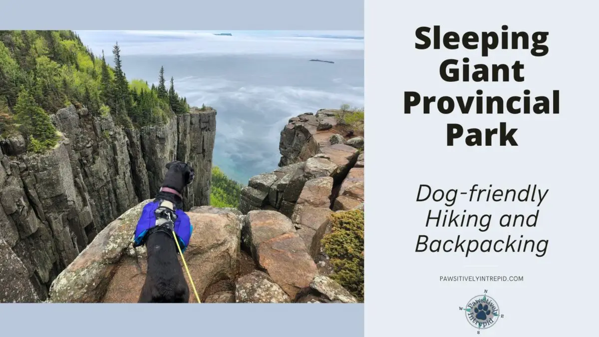
Sleeping Giant Provincial Park sits on a peninsula across from Thunder Bay, Ontario. Per Northern Ontario Travel, the park is named after an Ojibway legend, in which ” the Sleeping Giant is “Nanabijou” — The Spirit of Deep Sea Water — turned to stone when the white man was given the location of a nearby silver mine.”
If you look out at the peninsula from Thunder Bay, you can see the outline of the “Giant” at rest, sleeping on his back with his arms folded across his chest. Can you kind of see the outline in the photo below?

Sleeping Giant Provincial Park is home to over 60 miles of hiking trails and several lovely backpacking campsites (or a developed campsite and rental cabins if that’s more your style – yes there is one dog-friendly cabin). The hiking trails will take you through forests to the rocky shores of Lake Superior or up on top of The Giant for spectacular views of the surrounding area.
In 2022, on Memorial Day weekend, the weather was brisk and rainy with lows in the 40s and highs in the 60s. But the cooler weather meant almost no bugs and we nearly had the trails to ourselves, setting up our backpacking tent without any other campers in sight (or even earshot).
The Drive North
Connie and I both live in the Twin Cities area of Minnesota, so we had a 6.5-hour drive north to reach Sleeping Giant Provincial Park. The drive from the Twin Cities to Duluth is all highway driving with minimal scenery. But once you get north of Duluth, you are treated to the beauty of Minnesota’s North Shore. If you haven’t explored the North Shore, feel free to stop here and read any of the following blog posts to learn more about the beauty the North Shore has to offer.
- A Dog-Friendly Winter Weekend at the North Shore’s MN State Parks
- Oberg Mountain Loop: A Day-Hike with Stunning Views along the Superior Hiking Trail
- Thru-Hiking the Superior Hiking Trail with Your Dog
- Bear and Bean Lake Loop: A Dog-Friendly Superior Hiking Trail Day Hike or Overnight Adventure
- Tettegouche State Park: One of Minnesota’s Best Dog-Friendly Fall Hikes
Okay, back to our Sleeping Giant adventure. From Duluth to the Grand Portage/Pigeon River border crossing it is about 2 hours and 45 minutes. This was my second time visiting Canada, and my first time bringing a dog.
The entire process ended up being very simple. First, us humans needed to find our passports and COVID vaccination cards. Once those were located, we could download the ArriveCAN app onto our phones. Simply fill out the information in the app (or online if you don’t want to download the app) and the border crossing staff will have all of your information when you arrive at the border.
For Glia, all she needed was a copy of her rabies certificate (which to be honest the border patrol staff didn’t even take a look at). For dogs not old enough for a rabies vaccine, you may need proof of your dog’s age to verify that he or she is not old enough to be vaccinated yet.
To verify up-to-date information about bringing your dog with you on a trip from the United States to Canada, you can find official information here on Canada’s website.
Please also be aware that you are limited to a personal import of 20 kg (~44 lbs) of dog food. The dog food must be of United States origin and be commercially packaged. For more details about importing pet food into Canada, you can head over to Canada’s website on import policies.
The border control didn’t ask about Glia’s dog food but be prepared with your dog’s food in the original packaging as you cross the border.
After the border crossing, it was only another hour and 45 minutes to Sleeping Giant Provincial Park.
Sleeping Giant Provincial Park
We arrived at Sleeping Giant Provincial Park in the middle of some light rain and after checking in, we found that our original backpacking itinerary needed some adjustment. We had planned to park at the Kabeyun North Trail Head, but unfortunately due to the recent snow melt and lots of rain, the road to the north trailhead was closed.

So we changed our plan to park at the Kabeyun South Trail Head (one vehicle is included in your camping permit) and spend one night at a Sawyer Bay backpacking site and 2 nights at a Lehtinen’s Bay backpacking site. The nice benefit of this change in plans was that both of these backpacking sites provided a bear box for our food storage as well as access to privies. So we were able to leave our bear canister and trowel behind.
Backpacking Sites at Sleeping Giant Provincial Park
There are a total of 27 backcountry campsites in Sleeping Giant Provincial Park. These campsites are broken up into 7 zones. You will reserve a specific zone to camp in when you make your reservations. Within each zone, the individual campsites are first-come, first-served.
The descriptions of the 7 zones below are taken from the Ontario reservation site.
- Tee Harbour (10 campsites): “These high-quality, spacious sites, complete with access to Lake Superior, are often the first choice for backcountry campers at Sleeping Giant.“
- Lehtinen’s Bay (3 campsites): “The 3 signature campsites on Lake Superior at Lehtinen’s Bay are a bit deeper into the backcountry and remain frequently occupied.”
- Sawyer Bay (3 campsites): “The 3 large, solid campsites at Sawyer Bay on Lake Superior serve as a base-camp for summitting the Head and Chest of the Sleeping Giant.“
- Talus Lake (3 campsites): “The 3 small, non-private campsites along the Talus Lake Trail are the highest elevation sites in the park which places them beyond the comforts of Lake Superior.“
- Nanabosho (4 campsites): “The 4 very small campsites on the west-side of the Sleeping Giant lack privacy and separation from the Kabeyun Trail and are generally only used as stop-overs during longer excursions.”
- Twinpine Lake (3 campsites): “The Twinpine Lake Zone covers one of the most isolated sections of the park’s trail network and the 3 modest campsites here are infrequently occupied.“
- Finlay Bay (1 campsite): “This zone contains a lone campsite at Finlay Bay which requires an out-and-back hike.“
The first 3 on this list (in bold) are the most popular. As a result, the park has created shared bear-proof stainless-steel lockers for storing food at these locations. I failed to take a picture of the lockers, so please enjoy my artistic rendition below.

The sections of the lockers are fairly narrow. They easily held my single Ursack Allmitey (<— This is an affiliate link and I may earn from qualifying purchases. More affiliate links follow in this post) and probably would have held 2 Ursacks well. However, you likely wouldn’t be able to fit the full diameter of a bear canister inside the box sections.
For those of you who are not familiar with Ursacks, these are bags meant to be bear-proof (and/or critter-proof depending on the version you have). My bag is made to contain about 10 liters of food and smelly items. I do line my Ursack with an Opsack, which is essentially a thick plastic bag intended to help reduce how easy it is for bears and other critters to smell the contents of the bag.
If you choose to camp at one of the unbolded campsites, you will need to use a bear-proof system, such as a Bear Vault (or another bear-proof canister), an Ursack, or as a good tree hang. The park actually recommends a tree hang to store food (and other scented items), stating that “backcountry campers should hang their food out of reach from wildlife; at least 4 m above ground and 2 m from tree trunks.”
Personally, I am not great at hanging food securely, so I emailed the park to confirm that it was okay to bring a bear bag or canister. This was the reply I received: “Sleeping Giant Provincial Park recommends food/scented items are tied 4 metres up; however, if wildlife attractants are secured in a bear-proof container, they can be stored at lower heights.”
In addition to the bear boxes, the 3 bolded campsites also have metal firepits and access to privies. The other campsites have basic stone fire rings and no privies (so you must bring your trowel if you camp there). All campsites are marked with a blue-diamond tent symbol and have a maximum capacity of 9 people.
On our first night, we camped at Sawyer Bay and really enjoyed our campsite there. Two of the 3 campsites at this location are close together and near the bear box and an outhouse style privy. The 3rd is located a short walk down the trail, closer to the start of the Head Trail.
Since apparently, no one else wanted to backpack in light rain with lows in the 40s that weekend, we had the entire area to ourselves, so it felt really secluded and peaceful.


Above, you can see our campsite right next to the shoreline of Sawyer Bay. There was a nice fire pit and some logs to sit on. This campsite also had a picnic table next to the bear box for a good food prep area. And there were plenty of trees if you like to hammock camp. I took advantage of the trees to use Glia’s Hitch Hiker Leash to set up a little leash line for her.
(It was a little cold, so she is pictured wearing her Hurtta Expedition Parka.)
The second night, we hiked the Talus Lake Trail (more on this trail later) from Sawyer Bay to Lehtinen’s Bay. We passed by a couple of the backpacking sites in the Talus Lake zone, so I have included a picture of one of those sites just so you can see the difference in site development.

Although the rugged Talus Lake zone campsites had some appeal, when we arrived at the Lehtinen’s Bay campsites they were even better. The 3 backpacking sites at Lehtinen’s Bay are nicely spaced out. Each has there own privy and the second (or middle) site is closest to the bear box.


While the campsite itself is lovely, the real joy of these backpacking sites is the stunning rocky beach of Lehtinen’s Bay. So beautiful!
We were even visited by a beaver on the shores of this bay. It came out of the water and headed straight towards us. It got within 10 feet of us before I stood up so that it saw us and didn’t come any closer to my pup, Glia.
On our last day, we hiked out past the Tee Harbour sites, so for those interested, here are a few images from Tee Harbour. It looks like one of the best features of this zone is that some of the sites provide great access to a sandy beach to relax on. Other areas have a more classic rocky Lake Superior shoreline.


Okay, I hope that gives you a good idea of what to expect at some of the popular backcountry campsites. I don’t know what these areas will feel like during the busy season, but they were all absolutely idyllic in late May when we had the areas to ourselves.
Now let’s move on to discussing some of the great hiking at Sleeping Giant Provincial Park.
Hiking at Sleeping Giant Provincial Park
There are a lot of hiking trails open to you and your pup at Sleeping Giant Provincial Park, and unfortunately, due to weather, we were only able to sample a few of them. But in good weather, any of the hikes up onto the “giant” are worth the hike!
Sawyer Bay Trail
On our first day, we hiked from the parking lot to Sawyer Bay. This trail was a pretty average midwest trail through the forest. No stunning views and the trail is accessible to bikes, so not very technical for hiking.
Head Trail
After arriving at our campsite, we set up the tent, then attempted to hike the Head Trail (which came highly recommended by Pink Ribbon Runner). Unfortunately, it was still raining lightly and there were thick clouds. The trail is really steep (which I wasn’t expecting after hiking in on the gentle Sawyer Bay Trail) and without the views as a reward, I didn’t complete the full hike. But here are a couple of pictures from the climb.


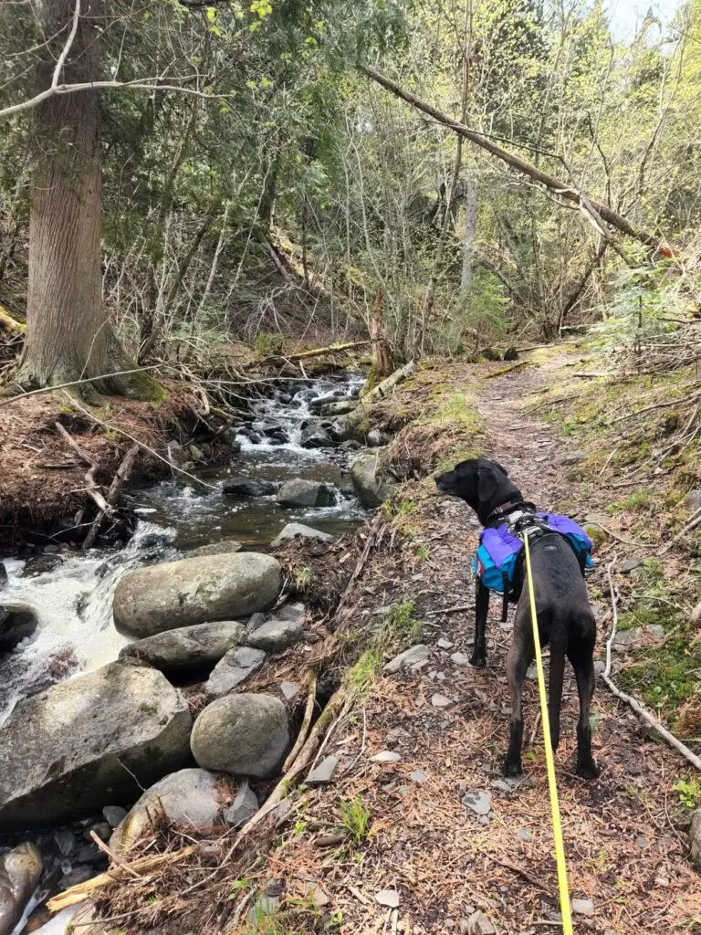
Talus Lake Trail
The next day, we took the Talus Lake Trail (4km or ~2.5 miles) from Sawyer Bay to Lehtinen Bay, and wow, was that trail nicer than the Sawyer Bay Trail. It felt like we had traveled further away from Minnesota to the foothills of a mountain range. There was elevation change, access to spur trails with amazing overlooks, beautiful lakes, and lovely streams flowing downhill.
The following photos are all from the Talus Lake Trail.


While Talus Lake Trail is wonderful all by itself, the most amazing views can be found on the spur trails: The Chest Trail and the Top of the Giant Trail.
If you only have time to hike one spur trail, make it the longer Top of the Giant Trail. But if you have time to hike both, hike both.
The Chest Trail
Since we were coming from Sawyer Bay and planning for 2 nights of camping at Lehtinen’s Bay, we hiked The Chest Trail on our way to Lehtinen’s Bay and hiked the Top of the Giant Trail the next morning.
The Chest Trail is 1 km (or ~0.6miles) one-way in length and is an out and back spur trail that can be accessed off of the Talus Lake Trail. There is a small amount of elevation change, but overall this trail was not very challenging compared to the Head Trail or Top of the Giant Trail. And you will be rewarded with wonderful views to the northwest.


The Chest Trail gave us our first chance to experience the amazing views that this park has to offer. It also provided a lovely spot to stop and take a snack break on our hike across this section of the park.
The Top of the Giant Trail
While we skipped the Top of the Giant Trail on our second day, we knew this trail was a highlight of the park. So after camping a night at Lehtinen’s Bay, we left our supplies at the bay and day hiked the Top of the Giant Trail on our 3rd day.
Top of the Giant Trail is a 2.7 km (~1.7 miles) spur from the Talus Lake Trail. We hiked a short portion of the Kabeyun trail to get to the Talus Lake Trail and then only needed to repeat a short 0.8km (~0.5 mile) section of the Talus Lake Trail before we started on the Top of the Giant Trail.
We had some intermittent thunderstorms during our hike up, but happily, the rain cleared as we reached the peak and we were rewarded with fantastic views. I would highly recommend this trail!
The best part is the gorge and cliffs at the end of this spur trail.


A wonderful backpacking trip
Because of the thunderstorms, we ended up cutting our visit to Sleeping Giant Provincial Park a day short. But we do hope to return in the future. This was a lovely dog-friendly park. And if you are up for some cooler spring weather, visiting at the end of May means that you may end up with many of the viewpoints to yourself. There weren’t even many bugs to contend with.
If you want to read more about some of the other hikes in the park (or just want a second opinion), I found this article by Pink Ribbon Runner to be helpful when picking which trails to hike.
Also, for those of you interested, Glia is wearing her Groundbird Gear Trekking Packs and Harness in many of these photos.
Have any questions about our visit? Let me know in the comments section below!


Thank you for sharing your experience we are headed to Sleeping Giant this weekend. I am curious about how well marked the Talus Lake Trail was. We had originally planned to hike that from Lehtinen’s Bay to Sawyer Bay, but heard that it was poorly marked and prone to wash outs which made me nervous about taking two teenagers into the wilderness on it.
Hi Rebecca! Thank you for your comment. I hope you have a wonderful time at Sleeping Giant.
Personally, I thought that the Talus Lake Trail was well marked. We hiked from Sawyer Bay to Lehtinen’s Bay. Hiking in that direction there were only 2 spots where the trail was a little hard to follow. The first was as we approached Talus lake. We missed a left-hand turn and followed a trail that proceeded a little further up the west side of the lake. It was easy to backtrack and find the main trail again. Coming from the other direction, this shouldn’t be a problem. The other spot that the trail was difficult to follow was through an area of rock on the east side of one of the lakes (honestly I can’t remember if it was Talus Lake or Helen Lake). There were signs designating the trail on each side of the rocky area, so if you just keep picking your way through you should see a sign sooner or later. If you have basic trailfinding experience, I wouldn’t expect you to have a problem. (Of course, I always recommend bringing a map, compass, and at least a phone GPS just to be safe). Enjoy your hike!